


Map System Reform and Regional Capital Operational Resolution
Authored by Kaevi
With this resolution, the author seeks to improve the regional map system for the future and legitimize the regional capital.
Authored by Kaevi
With this resolution, the author seeks to improve the regional map system for the future and legitimize the regional capital.
Article I - Map Reservation
Section A - All geographical maps of Earth shall have between eight and twenty-five percent of their habitable land reserved for nations making their initial claim.
Section B - Expansions by existing nations may not include land in the reserved area(s) and nations who made their initial claim in the reserved area may not expand further than three percent of their total land mass each expansion period if the expansion lies within a reserved area.
Section C - Nations may not make an initial claim within the reserved area(s) unless ninety percent of non-reserved land has been claimed.
Section D - Estimations as to the percentage of the map claimed shall be invested in the Map Commission (MC).
Section E - Establishes the areas highlighted in pink below in Figure 1 as reserved areas for the current regional map as of the date of passage of this resolution. These areas may be amended by the MC.
Section F - Establishes the names and continental boundaries shown in Figure 2 as the official names and continental boundaries for the regional map as of the date of passage of this resolution. The northwestern continent shall be named Illidia, the southern continent Terra Australis, and the middle continent with land connections to the former two continents as Medditerranea.
Section G - In the event that any of the reserved areas fall within a map claim posted before the passage of this resolution, the establishment of the reserved area shall prevail.
Section H - Existing nations may either donate tracts of land to become reserved area(s) or label certain areas of their lands as trust territories. In the event that all reserved areas are filled, lands labeled as trust territories will be automatically ceded to any nation making an initial claim.
Section I - In the event that a nation who claimed a trust territory ceases to exist within the region, the land will be ceded back to the original nation to which it belonged.
Section J - The map expansion period that occurred most recently to the passage of this resolution shall be deemed null and void.
Section K - Establishes Figure 4 as the official map to which all future claims are to be made. This map may be altered in any way the MC sees fit.
Article II - Map Commission
Section A - Establishes the Map Commission (MC) as a three-member body with administrative power over any Earth-based map of the region of Esamir.
Section B - Members of the MC may discuss topics in private before presenting their work, but may not withhold information regarding any changes made to the map or rules applied to its private functions.
Section C - All members of the MC have equal power within the Commission, regardless of seniority. Members of the MC shall be known as Associate Map Commissioners.
Section D - The MC has the power to approve any change to the map with a two-thirds majority among members.
Section E - The MC has the power to determine what time map expansion periods shall occur if at all, and alterations to the size and structure of the map.
Section F - The MC may set rules pertaining to its internal structure and procedures not listed within this resolution.
Section G - For the initial three seats, the nations listed in Article III shall take the seats.
Section H - Members may serve indefinitely unless removed by the Esamir General Assembly.
Section I - If a nation leaves the MC, a vacancy must be filled by an appointment resolution. The MC may not vote a member out of the Commission.
Section J - The Esamir General Assembly has the right to dissolve the MC at any time for any reason.
Article III - Map Commission Appointments
Section A - The nation of Eurasia shall take the seat of United Nations of Esamir Associate Map Commissioner.
Upon approval, the nation of Eurasia shall assume the role immediately and remain in the position until resignation or removal by the Esamir General Assembly.
Section B - The nation of Arveyres shall take the seat of United Nations of Esamir Associate Map Commissioner.
Upon approval, the nation of Arveyres shall assume the role immediately and remain in the position until resignation or removal by the Esamir General Assembly.
Section C - The nation of New Atanea shall take the seat of United Nations of Esamir Associate Map Commissioner.
Upon approval, the nation of New Atanea shall assume the role immediately and remain in the position until resignation or removal by the Esamir General Assembly.
Article IV - Regional Capital
Section A - Establishes the area encircled in pink in Figure 3 as the regional territory in which the capital resides.
Section B - The area encircled in pink in Figure 3 shall be known as the Esamir Capital Territory.
Section C - The Esamir Capital Territory may have laws set to it that may not be considered regional law.
Section D - All people within the region of Esamir are citizens of the Esamir Capital Territory.
Section E - Affirms that all chambers of the United Nations government must lie within the Esamir Capital Territory.
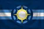
Section F - Establishes the flag shown in Figure 5 to be the official flag for the Esamir Capital Territory.
- Figure 1:

- Figure 2:

- Figure 3:

- Figure 4:

- Figure 5:

Last edited by Kaevi on Thu Jul 09, 2015 1:21 am; edited 5 times in total